Azov Sea (Lat. Palus Maeotis; The ancient-Greek Maiotis Limne is the Motian lake; Old Russian - Sourozhskoe) - Mediterranean Sea in the Atlantic Ocean pool, on Y. European part of the USSR. It is connected by Kerch Strait with the Black Sea area of \u200b\u200b38 thousand sq. Km, the average depth of 8 m, the maximum 14 m. The average water volume is 320 cubic meters. km. The shores on Z., S. and V. Mainly lowland, are composed of sand-andracked sediments; On Y. Coast predominantly obscure. Characteristic feathers of the coast of A.M. It is the presence of nasty sandy brass (Arabat shooter, Fedotova, Berdyanskaya, Yeisk, etc.), separating from the sea a number of shallow bays (Sivash, Crupping, etc.) and Limanov. Part of the estate is poorly connected with the sea (Yeysky, Baysugan), the other part is separated from it with sandy crops (lake dairy, Liman Long and others). Large open bays: Taganrog, located on S.-3., Temryuksky - on Yu.-V., Arabatsky - on Yu.-Z. Small lowland islands of turkey, sandy, turtle are located near the coast. In A.M. Large rivers Don and Kuban and numerous small rivers Mios, Berdy, Crupping, and others. Relief DNA A.M. Aligned, has a slight bias to the center. The soil is composed of sand, sewer and sludge. In the southeastern part of the sea are characterized by mud volcanoes.
Climate in the area of \u200b\u200bA.M. continental. Winter is cold, relatively dry, with the predominance of strong winds of the northeast and eastern directions. The average air temperature in January and February from -1 on Y. to -6 ° C on C., with a minimum temperature -30 ° C and below. Summer is roast, relatively humid, with the predominance of the winds of the Western direction. The average temperature in July 23.5, 24.5 ° C with a maximum of up to 40 ° C. Precipitation from 312 mm to 528 mm per year with their predominance in the summer months (1.5-2 times).
Hydrological mode. A.M. It is determined by its continental position, climate, river drain and water exchange through the Kerch Strait, as well as economic activities in the territory of the catchment. The main value is fresh component water balancewhich develops on average for the year from the mainland (39.6 cubic meters) and precipitation (13.5 cc) minus evaporation (33.9 ccm); Excess fresh water for the year is 17.4 cubic meters, which flow through the Kerch Strait. The flows form a general circulation counterclockwise. Under the influence of the eastern and northeastern winds of the flow may have the opposite direction. The water temperature has a sharply expressed annual move. In winter, it falls below about ° C, in the summer reaches 25, 30 ° C. The saltness of the water on Yu is 11%, on the rest of the sea 9-10 ° / oo, and in predominium areas decreases to 2-4%. Cf. Level A.M. Significant fluctuations (up to 33 cm) are subject to significant fluctuations. Episodic level changes depend mainly from the winds and can reach 5.5 m. The ice appears in November-December in the Taganrog bay and by the end of February and the beginning of March covers the entire area of \u200b\u200bthe sea. Cleansing from ice takes place in March - April. Fish resources A.M. Significant, which is determined by the exclusive biological productivity of A.M.: The content of organic matter is 5-6 times more than in other storm reservoirs. A sturgeon, bream, pike perch, taranu, fish, sphate, bulls, herring, hams, tulka, and other views are produced. A. m. It is also of great importance as a transport sea route for freight and passenger traffic. Main ports: Taganrog, Zhdanov, Yeisk, Berdyansk.
Used sources:
1. Edition 1969-1978; © 2001 Russian RUSS Portal Company Ltd. (electronic version), big Russian encyclopedia;
2. Dobrovolsky A. D., Zubdod B.S., Sea of \u200b\u200bthe USSR, M., 1965.
Azov Sea (Ukr. Azovska Sea) - the inner sea in the east of Europe. This is the smallest sea in the world, its depth does not exceed 14 meters. It is connected by Kerch Strait with the Black Sea, the geographic border with which runs along the line - Cape Takil (Kerchensky Persh) and Cape Panagia (Taman Persh). Refers to the Mediterranean System of the Atlantic Ocean.
Azov Sea from ancient times had of different nations Different names: Meotian Sea, Meotia Lake, Scythian ponds, Temeriad, Mother Ponta, Souroogo Sea.
Since the Azov Sea is quite shallow, the bottom of it is covered with or streamed in a mixture with a small shell, it quickly warms up, so ideal for relaxing with babies, because the water temperature in June is already 20-23 degrees.
General
The extreme points of the Azov Sea lie between 45 ° 12'30 "and 47 ° 17'30" North. latitude and between 33 ° 38 '(lake. Sivash) and 39 ° 18' Vost. longitude. Its largest length is 343 km, the largest width is 231 km; The length of the coastline is 1472 km; Surface area - 37605 km². (This area does not include islands and braids, occupying 107.9 km²).
According to morphological features, it refers to the plane seas and is a shallow water with low coastal slopes. According to the remoteness of the ocean in the mainland, the Sea is the most continental sea of \u200b\u200bthe planet.
Bathymetry
Underwater sea relief is relatively simple. As the depth is removed from the shore, slowly and smoothly grow, reaching 13 m in the central part. The main area of \u200b\u200bthe bottom is characterized by depths of 5-13 m. The area of \u200b\u200bthe largest depth is located in the center of the sea. The location isobat, close to symmetrical, is disturbed by a small elongation of them in the northeast towards the Taganrog bay. It is located about 2 km from the shore, moving around the Taganrog Bay from him around the Taganrog Bay and in the Bay itself near Done's mouth.
In the Taganrog bay, the depths increase from the mouth of the Don (2-3 m) towards the open part of the sea, reaching the bay of the sea 8-9 m on the border Western (banks Marine and Arabat) coasts, the depths of which are reduced from 8-9 to 3-5 m. For the underwater coastal slope of the northern coast, a wide shallow water (20-30 km) with depths of 6-7 m, for the southern coast - steep Underwater slope to depths of 11-12 m.
Area The waterboat of the Azov Sea basin is 586,000 km².
Sea shores Mostly flat and sandy, only in the south shore there are hills of volcanic origin, which in places go to steep advanced mountains.
Sea currents are depending on the very strong northeastern and south-western winds here and therefore quite often change the direction. The main flow is a circular flow along the shores of the Sea of \u200b\u200bAzov counterclockwise.
Salinity
The hydrochemical features of the Sea of \u200b\u200bAzov are formulated primarily under the influence of the abundant flow of river water (up to 12% of water volume) and difficulty water exchange with the Black Sea.
The salty of the sea before the regulation of Don was three times less than the average saline of the ocean. Its value on the surface was changed from 1 ppm at the mouth of don to 10.5 ppm in the central part of the sea and 11.5 ppm from the Kerch Strait. After the creation of the Tsimlyan hydraulus, the salinity of the sea began to rise (up to 13 ppm in the central part). Average seasonal oscillations of saline rarely reaches 1-2 percent.
Water contains very little salt in the northern part of the Sea of \u200b\u200bAzov. For this reason, the sea freezes easily, and therefore, before the appearance of icebreakers, it was disadvantage from December to mid-April. The southern part of the sea does not freeze and remains moderate temperature.
Fauna
The Izthyofaun of the Azov Sea currently includes 103 species and subspecies of fish belonging to 76 genera, and is represented by passing, semi-pass, marine and freshwater species.
The passing types of fish are poured into the sea before the occurrence of puberty, and the river can only be spawned. The period of reproduction in rivers and or on leaning usually does not exceed 1-2 months. Among the Azov passing fish are the most valuable fishing species, such as Beluga, Osperature, Sevryuga, Herring, Rybetka and Sweet.
Semisputing species for reproduction come from the sea in the river. However, in rivers, they can delay for a longer time than passing (up to the year). As for the juvenile, it rolls out of spawning, it is very slow and often remains in the river for wintering. The semi-pass fish includes mass species such as pike perch, bream, taran, Czech and some others.
Sea views multiply and fenced in salted waters. Among them are distinguished species that are permanent in the Sea of \u200b\u200bAzov. It is Pilengas, Kambala-Kalkan, Gloss, Tulka, Perkarin, Komashka Triochlag, Fish-needles and all kinds of bulls. And finally, there is a large group of marine fish, set in the Sea of \u200b\u200bAzov from the Black Sea, including regular migration. These include: Azov Hamsa, Chernomorskaya Hams, Black Sea herring, Barabul, Sincil, Ostronos, Loban, Calkan Black Sea, Studrid, mackerel, etc.
Freshwater species usually constantly live in one area of \u200b\u200bthe reservoir and large migrations do not commit. These species are usually despicable sea water area. There are such fish such as a sterling, silver crucian, pike, is, hiding, etc.
There are no equal in the world by the number of plant and animal organisms of organisms in the world. On productivity, the Azov Sea is 6.5 times higher than Caspian, 40 times - black and 160 times the Mediterranean Sea. But in size it is less black 10 times.
The Azov Sea is radically different from the other seas of the planet. It not only has no direct connection with the ocean, but also separated from it with two intermediate reservoirs - the Mediterranean and the Black Seas. The connection with the salty waters of the planet is carried out through a narrow Kerch Strait. Its width is only 4 km (in the place of the Taman Gulf 15 km). Length reaches 45 km, and the maximum depth is barely reaching up to 18 meters. Only through this is a narrow place and you can get to the Black Sea expanses, and then then on the immense wide mediterranean.
The length of the reservoir reaches 360 km, and the maximum width is 180 km. The area of \u200b\u200bthe water mirror is 39 thousand square meters. km. The volume of water reaches 290 cubic meters. km. And the depth for the sea is small. The deepest places are reached only up to 14 meters, and the average depth is 7.5 meters. The length of the coastline is 2686 km. That is, the reservoir is very small and small. The bottom of the hollow, the shore is low, only the hills are found on the southern coast. From the coast, the depth increases gradually. In winter, the sea is covered with ice crust. It is usually happening in January, rare in December.
Sea coast
Climate
Taking into account the fact that the reservoir is small and surrounded from all sides of the land, the climate on it is continual with a cold winter and a hot dry summer. In autumn I. winter The weather has a strong influence of the Siberian Anticyclone. It brings with me dry and cold air from Siberia. At the same time, the wind speed reaches 4-7 m / s with gusts up to 15 m / s. Such a guest can reduce the usual winter temperature minus 1-5 ° C to minus 30 ° C. The average summer temperature is 23-25 \u200b\u200b° C, and the maximum can reach up to 40 ° C. The sediment falls 1.5 times more than in winter.
As for the temperature of the water, then in the winter months it keeps at 0-1 ° C and 2-3 ° C in the Kerch Strait. In summer, the aqueous surface is heated to 24-25 ° C with a maximum of 28 ° C in the open sea and 30 ° C near the shore. IN summer period The surface of the sea is warmer than air. Since the Azov Sea is fine, then with depth the temperature is reduced by only 1 ° C. In the cold winters, the difference comes to 5-7 ° C.
Winds cause a storm. At the same time, the waves achieve a high height. For example, in the Taganrog bay, they are up to 6 meters in height. The southern coast of the wave usually does not exceed 2-4 meters, and in the Kerch Strait, only up to 1 meter approaches. In the open sea, the usual waves are 1-2 meters in height, sometimes 3 meters.
For reservoirs are characterized by frequent sewers. These are standing waves observed on closed water spaces. They are the result of resonant phenomena. That is, waves are reflected from the coast, they are superimposed on each other (interference) and increase if their amplitude oscillations coincides. Life expectancy of such a wave reaches several hours. Visually it looks like a lack of a wave moving from one water basin to another. Instead, a common wave is observed, which rises and falls on the same place. At the same time, the peak of the wave is constantly alternate with its base.
Except Seeshev are observed water vortices. At the same time, the water current prevails counterclockwise in connection with the Western and South-Western winds. The speed of such water movements usually does not exceed 10 cm / s, but if the wind is strong, it can reach up to 60-70 cm / s. In the bays, such streams are usually controlled by the runoff of rivers and are directed away from the coast. In the Kerch Strait, the stream is directed towards the Black Sea, as the northern winds prevail in these places. Its speed reaches 10-20 cm / s. In narrow places it reaches 30-40 cm / s.
Low water salinity contributes to its freezing in winter. Ice crust in the north can reach up to 7 km, and in the south up to 1.5 km. Ice is able to cover the water at any time from December to mid-March. But nowadays this has become a rarity due to common warming on the planet. But in the XVIII and XIX centuries it was the norm. Back in the 70s of the 20th century, the reservoir frozen every year in early February. The thickness of the ice reached 30-40 cm, and in the area of \u200b\u200bthe Taganrog bay, it reached 60-80 cm. The ice coating has always been characterized by instability. But be that as it may, in the winter months, navigation has always stopped.
![]()
Azov Sea on the map
Economy
In the north and west, the reservoir borders with Ukraine, and the east coast and part of the southern belong to Russia. Over the centuries, the Azov Sea was an important water for the carriage of goods and passengers. Ruda was mined at the Kerch Peninsula, and in Mariupol there was a factory for its processing (Azovstal, Were Zdanov's name). In Tsarist Russia, a metallurgical plant was also built in Yuzovka (Donetsk since 1923). Nowadays, Azovstal is, but there are no shaft. They were closed in 1990.
The navigation on the water has increased significantly after the construction of the Volga-Don Canal in 1952. He connected the Volga with the Azov Sea. Currently, the main ports are in Taganrog, Mariupol, Yeisk, Berdyansk. At the same time, salty water pollutes, which can lead to an ecological catastrophe in the near future.
There are real tragedies on the sea. On November 11, 2007, a strong storm caused the death of 4 ships in the Kerch Strait. Three dry cargos belonged to Russia. One ship went under the Georgian flag with a Turkish team on board. The storm also threw 6 other ships with anchors. All of them were thrown alarm, while 2 tankers were damaged. 1300 tons of fuel oil and about 6,800 tons of sulfur resulted in water.
A large place in the economy of the region is fishing. In the USSR, the catch was 300 thousand tons of fish per year. From the unit of the area of \u200b\u200bthe reservoir they caught more fish than in the Black and Mediterranean. In the current century, these indicators decreased significantly. Now it is taken to install fish for breeding, especially sturgeon.
Rivers flowing into the Azov Sea
The largest river falling into the Azov Sea is the Don River. Its length is 1870 km. Below, Rostov-on-Don River forms a delta, which is 540 square meters. km. These are numerous sleeves and ducts ending your way in the Taganrog Bay.
In the southeast in the sea, the Kuban River flows, taking his origin on Elbrus. Its length equals 870 km. At the place of failure in the salt, the Kuban delta with an area of \u200b\u200b4,300 square meters forms. km.
From Donetsk ridge carries his waters river Calmius. It reaches 209 km long. Water stream flows through Donetsk, and mouth is within Mariupol. Small Utonuk, Bird, Hay, Duch and other rivers of medium sizes are also falling into the sea.

Children on the shore of the Azov Sea
Water exchange
It feeds the salt water not only at the expense of rivers, but also due to precipitation. The annual influx of river water is an average of 38.6 cubic meters. km. And the preciputes give 15.5 cubes. km. Evaporation make up 34.6 cubic meters. km. From the Black Sea annually comes 36-38 cubic meters. km of water, and goes back 53-55 cubic meters. km. Thus, the Azov Sea annually gives 17 cube southern neighbor. km of water.
The reservoir level is slow, but steadily decreases. Specialists are blamed in this numerous hydroelectric power station on rivers. Another 30 years ago, the depth of 16 meters was not unusual. Nowadays there are no places deeper than 13.5-14 meters. During the year, the water level fluctuates on average by 20 cm due to the melting of snow in the spring.
origin of name
This small salty reservoir Greeks was called Motion Lake. On his shores there was a Bosporian kingdom, who conquered the tribes of Merotov, who lived on these lands. Scythians gave salted reservoir name Kargaluk. And the Turks, looking at the Azov Water surface, said: "Bahra Assak". Mongolian conquerors, besieged horses in the coast shrinking waves, said: "Balyk Dengiz". What meant "Fish Sea". But all these names are not like modern.
Most likely, it has Turkic roots, that is, it came from Altai lands along with nomadic tribes. In this language, a small river, flowing in Don, was named. Azovka - so called its locals. Subsequently, the city of Azov was laid in these places. Well, it received the appropriate name and the sea. But the familiar to all the combination of words was officially official in the second half of the 18th century. Since then, it remains unchanged and appears in all geographical directories and on the world's maps.
Yuri Syromyatnikov
The Sea of \u200b\u200bAzov on the map is a semi-folded water area of \u200b\u200bthe Atlantic Ocean. There is an object in the eastern part of Europe. Two countries have on their territory Azov Sea - Ukraine and the Russian Federation.
general information
The Azov Sea is considered the most small in the world. Its maximum depth is no more than thirteen and a half meters, and the average (according to various estimates) is within 6.8-8 m. In the area where the Azov Sea is located, other properties connecting the water area with the Atlantic Ocean are located. Among them should be noted the straits of Kerch and Gibraltar, Bosphorus and Dardanelles. In addition, the links are Mediterranean, Aegean and Black Sea.
History
Previously, in antiquity, where the Azov Sea is now, there was no water. Filling the water area allegedly began in 5600 BC. e. At that time, fell into the Black Sea directly in the field of the current Kerch Strait. In that area where the Azov Sea is located, there are different settlements. The names of many of them went on behalf of the reservoir. For example, Stanitsa Priazovskaya and Azov, the city of Azov, which is located in the lower reaches of the river. Don, Novoazovsk and others.
Name
In ancient times, the water area was called different people in their own way. It should be said that the sea was renamed quite many times. Until today, the exact origin of the name has not been established. There are several hypotheses on the etymology of the original word "Azov":
- named Prince Azuma killed in 1067;
- by the name of the "Assa" tribe, which, in turn, occurred presumably from Avestian and means "fast";
- according to Circassian "Uzev", which means "neck";
- according to the Turkic Word "Azan" - "Lower".
Back in the distance I. n. e. In his writings, lifting the Scythian tribes, says about the settlement "Askoki". The name is similar to the word "Azov". It is believed that the modern name of the water area began to be used in Russian toponymy since the beginning of the 17th century, thanks to the chronicler Pimen. At the same time I must say that the original name received not all of the Azov Sea (on the map of Russia near the one of the name of the name, the part of Taganrog is located today). And only by the 2nd half of the 18th century, the name was fixed behind the whole water area. 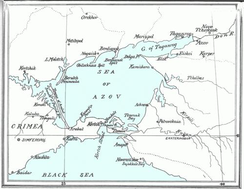
Research
The history of studying the area where the Azov Sea is, it is conventionally divided into several stages.
- Geographical (ancient), which continued since Herodotus before the early 19th century.
- Geological and geographical. He lasted from the 19th century until the 40s of the 20th century.
- Complex. This period began from the mid-20th century and continues to today.
Claudide Ptolem was composed of the first map of Ukraine as such as then did not exist, and the position of the reservoir itself relative to other objects was not quite understandable. Ptolemy installed the first geographic coordinates for cities, bays and capes. Subsequently, Gleb Svyatoslavovich, Rule in 1068 in Datmutarakani, I measured the distance from Kerch to Taman. It was approximately 20 kilometers at a time. Already from the 12-14th centuries, Venetians and the Genoese began to make maps and the location of the Azov and Black Seas. 
Geographical position
The area where the Azov Sea is, runs between 45 ° 12'30 "and 47 ° 17'30" s. sh. and 33 ° 38 'and 39 ° 18' in. d. The maximum reservoir length reaches 380 kilometers, and the width is 200 kilometers. The coastline has a length of 2686 km, the surface of the water area covers an area of \u200b\u200b37,800 square meters. km (the braids and islands are not included in this figure, which are distributed in the territory of 107.9 square meters. km). In accordance with the morphological signs, the object refer to the category of flat seas. The reservoir is considered shallow water, having low shores of the coast. The Sea of \u200b\u200bAzov (on the map of Russia it is clearly seen) is quite removed from the ocean. In this regard, the object refers to a group of continental reservoirs. In winter, the Azov Sea can completely or partially freeze. The ice is made in the Kerch Strait. Usually the formation of ice begins in January. In the cold years it can happen for a month earlier. 
Bathymetry
The place where the Azov Sea is located, is distinguished by a relatively simple underwater terrain. In the course of removal from the coast there is a smooth and slow downstream of depths. In the central part of the water area, they reach 13 meters. Here are the depths of maximal. The location isobat, close to symmetrical, violates the small stretch of them towards the northeast to the Taganrog bay. Approximately two kilometers from the shore is a 5 meters from the shore. It is removed from and around the mouth of the Don River. In this section, the depths increase towards the open part of the reservoir. At the border of the sea and the bay, they reach eight-nine meters. The bottom relief is distinguished by the presence of systems of underwater elevations. They are elongated along the Western (Arabat and Maritime Banks) and Eastern (Izinsk Bank) coarse. Depths are reduced from 8-9 to three to five meters. For the coastal underwater slope on the north coast is characterized by a fairly wide shallow water. Here, the depth of 6-7 m. The southern coast is characterized by a steep underwater slope. Depths in this area - 11-13 meters. Sea shores, as a rule, sandy and flat. In the southern plot, however, you can find hills having volcanic origins, and in places passing into advanced steep mountains.
The area of \u200b\u200bthe catchment in the pool is about 586,000 square meters. km. The flows depend on the minimal strong winds of the northeast and south-western directions. The main movement occurs along the shores. Its directions back clockwise. 
Temperature mode
For shallow reservoirs, a large seasonal temperature variability is characteristic. In winter, the indicators reach a minimum. In January-February, the values \u200b\u200bare close to the freezing temperature. In the southern part of the reservoir, not far from the Kerch Strait, the thermometer pillar rises above zero. Temperature amplitude per year - + 27.5 ... + 28.5 degrees. IN summer time On the entire surface of the sea, quite homogeneous indicators are noted - from +24 to +26 degrees. In July, in some areas (for example, such as the sea is heated as much as possible to +28 ... +28.5 degrees. The most heat was recorded in Primorsko-Akhtarsk. It was +32.5 degrees. As for many years of average annual temperature, it is located on the surface within 11 ° C. Inter-annual oscillations are about one degree. 
Salinity
The Azov Sea has hydrochemical features. They are formed mainly under the influence of a rich river inflow (about 12% of the total volume of water). In addition, there are several hindered water exchanges with the Black Sea. Until the register of Don, the salinity of the reservoir under consideration was lower than the ocean. three times. Indicators changed from 1 ppm at the mouth of the river to 10.5 in the central part and to 11.5 in the area of \u200b\u200bthe Kerch Strait. It began to rise after the construction of the Tsimlyan hydraulic dispenser. By 1977, the average rates increased to 13.8 ppm, in the Taganrog bay numbers were slightly lower - 11.2. During relatively high moisturies, a rapid decrease in salinity was observed. It was 10.9 in that period. However, by 2000, the indicators rose again, stabilized at 11. It should be said that in the northern part of the reservoir there is little salt, in contrast to the site, to which the Crimea is adjacent. The Sea of \u200b\u200bAzov (a map showing the location of the object is presented below) in the area of \u200b\u200brichly self-sample salt. She was mined from ancient times. Until the end of the 19th century, salt from this site ensured Russia's needs almost half. The greatest value The salinity of water reaches in solution - rape of Siva and other lakes. This is due to intense evaporation from the water surface in the summer. All these hyperweed areas are large renewable mineral salts, which are known to the Azov Sea. Russia, having these objects, provides itself with a significant amount of this mineral. Because of communication with the sea, their rappi composition is similar to the structure of sea water. Mostly in the rape there are sulfates and chlorides of magnesium and sodium. 
Water
The Azov Sea is characterized by low transparency. Every time of year and in various districts it is different. Indicators vary in the range from 0.5 to 8 meters. Low transparency is mainly due to the intake of a large number of river waters, a fairly fast clutching of bottomals during the excitement of water, as well as the presence of plankton mass in the reservoir. The lowest indicators are noted in there transparency is in the range of 0.5-0.9, in rare cases - 2 meters. Water in this area can change its color from greenish yellow to brownish yellow. In the central part of the reservoir because of the large depths and under the influence of the Black Sea currents, transparency can be from one and a half and two and a half to eight meters. Here water has a greenish blue color. Almost everywhere in the summer there is an increase in transparency. And in some areas due to the sufficiently rapid development of the smallest animals and vegetable organisms in the upper layers, the indicators fall to zero. And the water becomes bright green. This phenomenon is called "Flowering Sea".
Hello everyone!!!
I am writing with you again. Because of the heat, no crashes and trips did, unfortunately.
But it was well well, recovered (every 2-3 kilogram scored), got hardened, tanned and ... Finally came. Two days came to themselves, again cooking-cleaning-washing (who would take over, well, even occasionally). Well, oh well, and so smashed for this summer.
So, Azov Sea.
The Sea of \u200b\u200bAzov is the smallest sea in the world, the maximum depth is less than 15 meters, approximate dimensions - 350 km by 230 km, the Azov Sea connects to the Black Sea through the Kerch Strait. The petty Azov Sea quickly warms up - already in May water in many places warmer 20 degrees, summer warmer black at least 2-3 degrees, the temperature sometimes reaches 28. The largest rivers flowing into the Azov Sea - Don and Kuban.
Why is the Azov Sea so called?
Which names did not give him people who lived on his shores.
Ancient Greeks called Meoty Lake; Scythians - Cargaluk; Meota - Temerinda (that is, the "mother of the sea"); Arabs - Nitshlah or Bahr al-Azuf; Turks - Bahr El-Assak or Bahr-Ya Assak (Dark-Blue Sea).
Oriental Slavs called him in the blue sea.
After the formation of the Tmutarakan principality, the sea began to call Russian. With the fall of the principality, the sea is renamed repeatedly (Samakush, Salakar, Mautis, etc.).
At the beginning of the XIII century. The name of the Saksin Sea appears. Tatar-Mongol conquerors replenished the collection of Azov's names: Balyk-Dengiz (Fish Sea) and Chabak Dengiz (Chabacier, Bloomy Sea).
There were other names: Barel-Azov (Dark Blue River); The Thracian Sea (under Thracians were understood by the Genoese and Venetians); Souroogo Sea (the modern city of Sudak in the Crimea was souched); Caff Sea (Caffa - Italian colony on the site of the modern city of Feodosia in the Crimea); Kimmerian Sea (from Kimmerians); Akdense (Turkish, meaning the White Sea).
The Turkic adjective azak (the Turkic mouth of the river), meaning low, lowered - transformed into Azau, and then to Russian Azov.
But most reliably, that the modern name Sea received from the city, which in 1067 was captured by Polovtsy; They gave him the name of Azak, subsequently turned into azov.
History of the village of Urzuf.
Greeks came out of the Crimea in July 1777. All Greek immigrants were 19800 people. And from the priazovsky steppes in the Chumatkom tract included in the Ekaterinoslav province. Here they broke into two branches: some of the Greeks remained in Novomoskovsky, and the other part went to the Bakhmutic province (now Artemovsk - my hometown).
Two years lived the Greeks in the Bakhmutic province. The process of degradation of Greek culture began: loss of language, customs, morals. Metropolitan Ignatius Gozadinov - Gothic, Cafai, in the Crimea, and then in the Azov region, could not look at it indifferently. In early 1778, he visited Empress Ekaterina II in St. Petersburg with the Great Past: "Dear Empress Catherine Great! I ask you to save my flock, - to move the Greeks closer to the water, they can't live without water, like frogs, as the great Aristotle said. " The Empress gave good. In the autumn of 1778, it gives instructions on the resettlement of the Greeks to the Azov province; On the shores of the Northern Priazia.
These were immigrants from the Crimean villages Gurzuf, Kizil Gasi and Majar. They founded 22 villages and the city of Mariupol. At that time, the priazle steppes were empty and lifeless. Scythians called this steppe "aciaria", which means fertile, but wild. On the territory of modern Urzuf was one single house in which Cossacks lived - two brothers Demyan and Dmitry by the name Kovalev.
They are sheltered immigrants in their wintering. And from the spring 1779, the Greeks settled and began to master new lands. So the village of Urzuf appeared.
Urzuf Continuing to landslide and develop thanks to the prosperity of the resort business.
Here we rested in the wellness complex of the "Urzuff" wellness complex, it is 50 km from the city of Mariupol.
Power was included in the cost of a ticket, hence 3 kg of live weight.
There is a bar, dining room on site,
library, tennis courts, volleyball, dance, playgrounds.
Cases for accommodation varying degrees of comfort: three-story buildings with cozy rooms, but toilet + shower + washbasin at the end of the corridor; with washbasins I. cold water in each room, but without other amenities; More and more buildings are recently rebuilt into fully comfortable - junior suites and suites.
We lived in five-story with hotel rooms (with amenities in every room), however, shower on the street. We whispered in secret that this building will begin to rebuild it in September.
All buildings are combined with a huge park, with cozy allems, arbors.
Subtropic plants, of course, no. The decorative dwarf rowan is found, but, mostly, pine Mugus with huge needles, gorgeous blue spruce, birch ...
In June, the katalpi flowers beautifully bloom. Catalpa - the Indian name of the tree, originally from Central China, oddly enough - "national" trees of France - how do you like it? Wonderful natural.
By the way, it is very beautiful tree With a lush crown that gives a lot of shadow. The fruit is a long hanging, like a pod, box.
The fruits remain hanging on the branches almost all winter, giving the tree a rather original species. It is often called "summer chestnut" - for the similarity of inflorescences with chestnuts.
The territory of the recreation center is highlighted in dark time The day and is guarded around the clock.
It is enough to go from the 50-100 meter housing along the alleys of the boarding house and staircases
and here we are on the shore of the Azov Sea.
The beach is own, fenced specifically for vacationers, with shadow canopies, beach beds and shower and changing cabins. Sand, a little shell. My taste is the best in the ultrasound beach!
The most unforgettable time for swimming in the Sea of \u200b\u200bAzov is an early morning. The first rays of the sun, full of calm, transparent and warm water - Only in order to see it and feel it is worth come here. Look at the slideshow. I tried to show the morning sun, and entertainment on a hot day, and sunset:
To our services: flying on a parachute, riding on inflatable slides and bananas, scooters, bicycles, beautiful fishing.
There are several other tourist databases and children's camps in the village. But evenings are boring.
The main "entertainment" is located in the central part of the village. The center of cultural life is considered to be the moon - the park and part of the avenue, stuffed with all sorts of cafes, skewers, cheburechny and ... all.
Vacation succeeded. "UrzUF" is not only a beach holiday, but also rehabilitation, as water in the Sea is a healing. Therapeutic sea air is saturated with all sorts of healing elements (calcium, iodine, bromine, as well as by the head of steppe herbs).
All photos in albums.
Historical certificate from Azov-style sites and recreation in ultrasound


